Research and Surveying with Deeper Sonar

✓ Create bathymetric maps using built-in GPS or phone/tablet GPS with all maps and scanning history saved on your device and accessible on any computer.
✓ Export raw depth map and sonar data and process it in any software of your choice.
✓ All charts free and downloadable, and all maps automatically transferred to the Fish Deeper™ web portal.
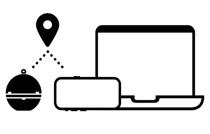
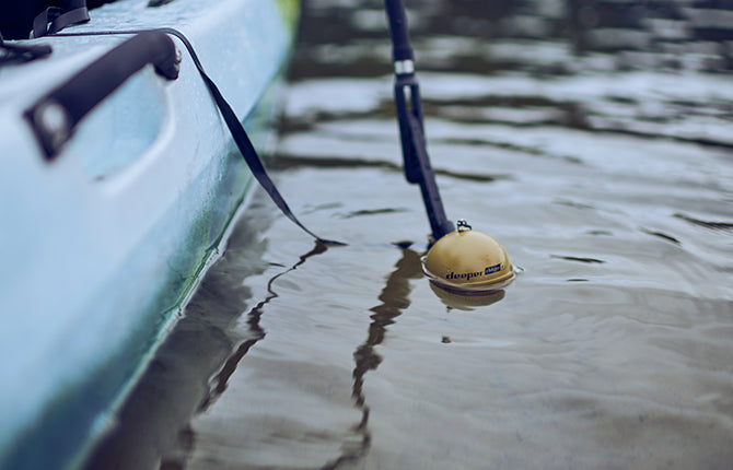
✓ Deeper sonars are wireless, very light, small and do not require a complex installation on a boat. They are easily transportable and can be quickly deployed.
✓ An inexpensive solution compared to industrial grade sonars. For those who require high precision, Deeper sonars act as a great tool for conducting preliminary pre-surveys before employing industrial grade sonars.
Choose Your Deeper for Research and Surveying
-
Deeper Sonar PRO+ 2
Regular price €229,00 EURRegular priceUnit price per€0,00 EURSale price €229,00 EUR

Powerful, Versatile Smart Sonars
-
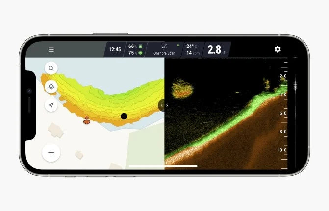
Sonarauslesung und Export. Verschaffe dir einen Überblick über Bodenbeschaffenheit und -härte, orte Fische und Unterwasserobjekte. Analysiere deine Tiefenkarten und Sonardaten über das Smartphone- oder die Web-App. Exportiere Roh- und Sonardaten.
Für mehr als nur Angeln. Deeper-Sonare wurden entwickelt, um gute Angelstellen zu lokalisieren. Sie wurden nicht für industrielle/wissenschaftliche Vermessungszwecke entwickelt, haben aber dennoch das Interesse von Menschen und Organisationen verschiedener Berufsgruppen geweckt und dienen nun als großartiges Werkzeug für Hydrographen, Umweltwissenschaftler, Universitäten, Bauingenieure, Taucher und viele mehr.
Integriertes GPS. Deeper Sonare haben ein eingebautes GPS (PRO+, PRO+ 2, CHIRP+, CHIRP+ 2), mit dem Tiefenkarten erstellt werden können, während Sie das Sonar vom Ufer aus auswerfen oder es mit einem ferngesteuerten Boot oder einer Drohne transportieren. Sonarmodelle ohne GPS können weiterhin Tiefenkarten von kleinen Wasserfahrzeugen aus erstellen (Boot, Kajak, Ponton, SUP-Board usw.), indem sie das GPS Ihres Telefons oder Tablets nutzen. Sie können auch Ihren eigenen GPS-Empfänger verwenden, um die Präzision zu erhöhen.
Leicht und einfach zu transportieren. Keine komplexe Installation auf einem Boot erforderlich. Deeper Sonare sind leicht und einfach zu transportieren. Sie können schnell eingesetzt werden, was für die Tiefenmessung in mehreren separaten Gewässern sehr nützlich sein kann (z. B. Solebädern) oder Vermessungen in abgelegenen Gebieten wie alpinen/vulkanischen Seen durchführen müssen.

Wireless, Simple Solution for Bathymetric Data
-
NMEA0183-Daten. Verbinden Sie das Sonar (CHIRP+ 2, CHIRP+, PRO+ 2) mit nahezu jedem Gerät und empfangen Sie die folgenden NMEA-Nachrichten über UDP: $GPGSA; $GLGSA; $GAGSA; $GNRMC; $GNVTG; $GPGSA; $GLGSA; $GAGSA; $GNRMC; $GNVT; $GNGGA; $SDDBT; $YXMTW.
Exportierbare Daten. Tiefendaten lassen sich als .CSV-Datei mit folgenden Informationen exportieren: Breitengrad, Längengrad, Tiefe, Zeitstempel, Wassertemperatur. Diese Daten können dann in eine GIS-Software zur Erstellung von 2D/3D-Karten exportiert werden.
Rohsonardaten lassen sich ebenfalls problemlos als .CSV-Datei exportieren. Die exportierte Datei verfügt über einen Zeitstempel für jeden Sonar-Ping sowie die Echostärke für jede Wassertiefe.
Wi-Fi-Verbindung. Deeper-Sonare nutzen Wi-Fi, um sich mit einem Smartphone oder Tablet zu verbinden, und ermöglichen eine drahtlose Verbindung über eine Reichweite von bis zu 100-120 m. Mit Wi-Fi-Extendern lässt sich die Reichweite erhöhen. Deeper erzeugt sein eigenes Wi-Fi-Signal und kann überall auf der Welt verwendet werden

Specifications
Deeper sonars can be great tools for bathymetric map creation and scientific research and surveying.
✓ 3 angle beams (47°/ 20°/ 7°)
✓ Casting range up to 100 - 120 m / 330 - 394 ft (depending on model)
✓ Depth range up to 100 m / 330 ft
✓ Operating time up to 8 - 15 hours (depending on model and usage conditions)
✓ Operating temperature from -20°C to 40°C / -4°F to 104°F
Experiences from the Field
-
Getting Better Sludge Maps
Philip Fandrick
Elemental Bioremediation Inc.
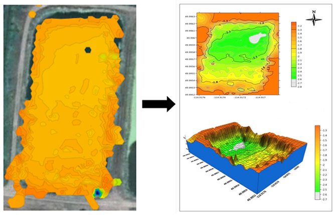
Die Situation: Erstellung von Tiefenkarten kleiner landwirtschaftlicher Teiche sowie kommunaler Stauseen und sogar Klärteiche.
"We started off by casting it just to get depth measurements. We then saw that we could do so much more with this little device. We have since fitted this device to a remote control boat and use it in boat mode with an iPhone on the RC boat. We use it to build full-on maps with it. This gives us better sludge maps on sewage lagoons than the old way of using a sludge judge throughout multiple locations on a lagoon. It is also safer since we need not send someone out on a boat on top of a sewage lagoon anymore."
"The raw data works great to input into CAD programs in order to produce some very nice maps."
-
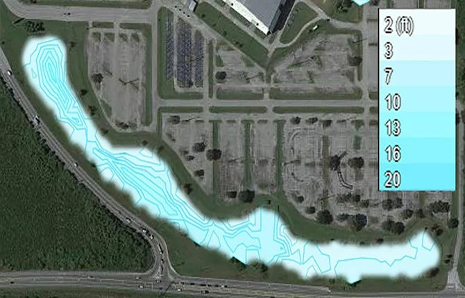
Data for Treating Water Bodies
Devin Crosbie
FloridAquatic Inc.
Die Situation: Instandhaltung von Seen und Regenrückhaltebecken für HOA-Gemeinden, Golfplätze und Regierungsbezirke.
"We are just getting started using Deeper, and so far we’ve bathymetrically mapped about 8 lakes. The mapping is a new service we're offering to our clients. Outside of that, the Deeper PRO+ has been very useful in quickly casting out and gathering depth readings, which are then used to calculate the amount of chemical needed to treat certain water bodies."
"Very useful in quickly casting out and gathering depth readings."
-
Verifying Water Depths
Curtis Weychert
Abteilung für Umweltschutz, North Carolina
Die Situation: Arbeitet für eine Umweltbehörde und muss ständig Wassertiefen für die Erschließung im Wasser überprüfen.
"Not only do we use the Deeper to get specific areas of depth, but we use the bathymetric feature to identify things like deep water channels in shallow bays and sounds to aid in navigation decisions. We use the bathymetric feature to ensure that points of ingress and egress are not blocked, impacted, or otherwise unusable. Using tidal data from nearby buoys, along with using Deeper at low tides, we can interpolate the average depths relative to MLW or MLLW to ensure that the water depths at low tides wouldn’t cause impact to the bottom habitat through various kinds of development. The Deeper allows us to cast in various areas from shore and determine, through the bathymetric composite mapping, where the deepest waters and channels are."
"Product is accurate, easy to use, and affordable."


-
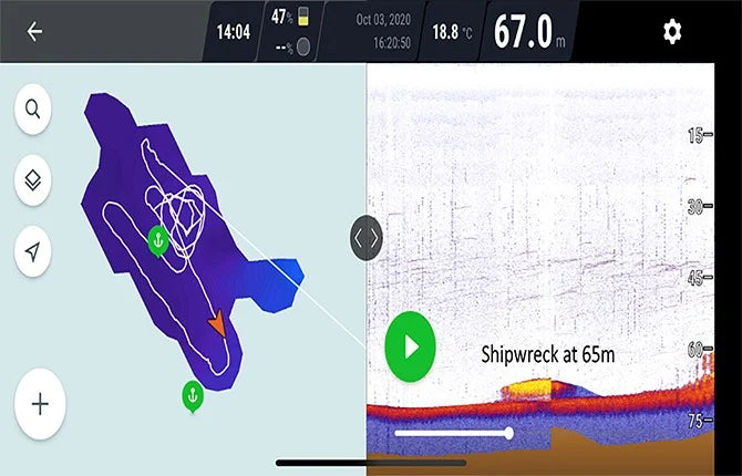
Finding Shipwrecks
Marc-André Dubois
TaucherDie Situation: Einsatz des Deeper CHIRP+ für die Wracksuche bei Tauchexpeditionen.
"There are not many accessible products for divers who want to find shipwrecks and we usually buy fishing side scanners or sonars as they are relatively precise. We really enjoyed the product. I was really impressed by the quality of the product, software and hardware. I tried much more expensive and bulky units and the CHIRP+ gives similar or even better results."
"Really impressed by the quality of the product, software and hardware."
-
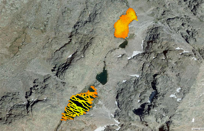
Reaching Very Remote Areas
Meeresökologe
Die Situation: Erforschung von Bergseen.
"We use a very small boat (50 cm long) with the sonar floating in the centre of the boat (and the cellphone aboard) and move it with ropes from one shore to the opposite, so even we don't need to carry a big boat for us."
"We can access very remote lakes to get bathymetric data with a very light equipment and very good resolution."


Contact Us
Have questions or want to find out if Deeper Sonars are suitable for your purposes? Get in touch with us! We'll get back to you within 1 business day.